Visualising Australasia’s Soils Background Technical Build Environmental Monitoring Rainfields

Rainfields (Rainfall Mapper)

Rainfields (Rainfall Mapper) is a high-resolution rainfall-mapping tool that helps users visualise how rainfall varies across landscapes in near real time.
Developed by Dr Peter Weir and the CeRDI technical team, the system combines radar and gauge data from the Bureau of Meteorology to reveal detailed rainfall distribution at a 500 × 500 metre grid resolution.
Unlike traditional point-based gauges, it measures rainfall across an area, allowing farmers, researchers, and environmental managers to explore spatial rainfall patterns at both regional and paddock scales.

Key Features

  • High-Resolution Data: Displays rainfall variability within 500 m tiles, capturing localised weather events such as thunderstorms.

  • Integrated Data Sources: Combines BoM radar imagery with national rain-gauge readings to create the Rainfields-3 dataset hosted by NCI (National Computing Infrastructure).

  • Real-World Applications: Supports decision-making in farming, flood management, biodiversity monitoring, and climate-change research.

  • Historical Insights: Provides access to two years of rainfall history for comparison and trend analysis.

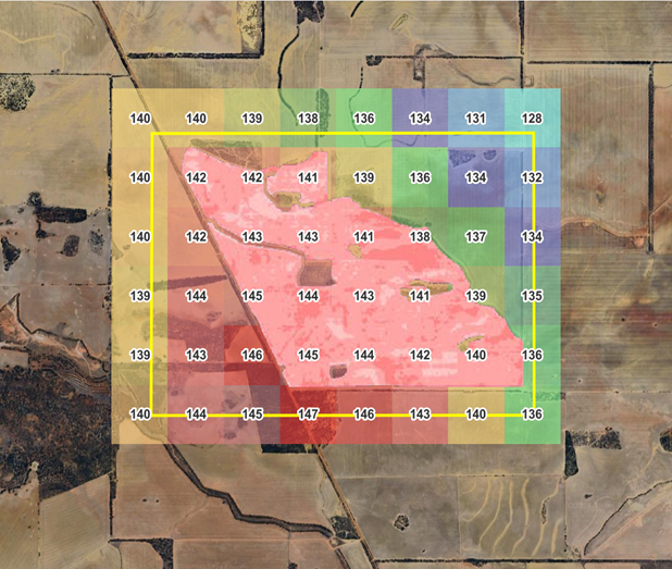
Figure: Detailed image from Rainfall Mapper of a paddock in Kalannie WA (Jan-May 2024 summed rainfall).

Technology Behind Rainfields

  • Data Integration: BoM radar + gauge data processed into high-density rainfall grids.

  • Backend: Built and managed through CeRDI’s secure data infrastructure.

  • Processing Engine: Converts rainfall data into spatially mapped tiles, enabling visual overlays with soil-moisture and monitoring-site data in the VAS platform.

  • Future Development: Work is underway to translate rainfall grids into soil-moisture estimates, enhancing land-water modelling accuracy.

Visualisation

Interactive maps allow users to:

  • View rainfall accumulation over specific time periods.

  • Compare paddock-level rainfall with surrounding regions.

  • Analyse changing rainfall patterns across Australia using the Rainfields coverage layer.